Toronto Sunset

3
Read more

Toronto Harbor

0
Read more

Canada Parliament Historic Building

0
Read more

Toronto Before the Dawn

0
Read more

Toronto City Night View

0
Read more

Yacht Club at Noumea

0
Read more

Chess Set Collection: The Move

0
Read more

Canada Maple Leaf Flag

0
Click on the photo to download without watermark.

The National Flag of Canada[1], also known as the Maple Leaf, and l'Unifolié (French for "the one-leafed"), is a red flag with a white square in its centre, featuring a stylized 11-pointed red maple leaf. Its adoption in 1965 marked the first time a national flag had been officially adopted in Canada to replace the Union Flag. The Canadian Red Ensign had been unofficially used since the 1890s and was approved by a 1945 Order-in-Council for use "wherever place or occasion may make it desirable to fly a distinctive Canadian flag".[2][3] In 1964, Prime Minister Lester B. Pearson appointed a committee to resolve the issue, sparking a serious debate about a flag change. Out of three choices, the maple leaf design by George F. G. Stanley and John Matheson based on the flag of the Royal Military College of Canada was selected. The flag made its first appearance on February 15, 1965; the date is now celebrated annually as National Flag of Canada Day.[4]

Many different flags have been created for use by Canadian officials, government bodies, and military forces. Most of these flags contain the maple leaf motif in some fashion, either by having the Canadian flag charged in the canton, or by including maple leaves in the design. The Royal Union Flag is also an official flag in Canada, used as a symbol of Canada's membership in the Commonwealth of Nations, and of its allegiance to the Crown. The Union Flag remains a component of other Canadian flags, including the provincial flags of British Columbia, Manitoba and Ontario.[5]

(Source: wikipedia)

Read more

Terraces of Paddy Field at Bali

0
Click on the photo to download without watermark.


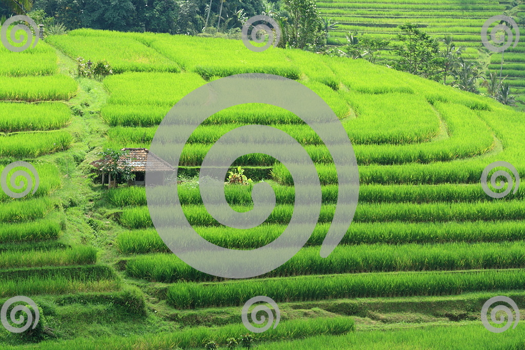
A paddy field is a flooded parcel of arable land used for growing rice and other semiaquatic crops. Rice can also be grown in dry-fields, but from the twentieth century paddy field agriculture became the dominant form of growing rice. Paddy fields are a typical feature of rice-growing countries of east, south and southeast Asia, including Cambodia, Bangladesh, China, Taiwan, India, Indonesia, Japan, North Korea, South Korea, Malaysia, Myanmar, Nepal, Pakistan, the Philippines, Sri Lanka, Thailand, Vietnam, and Laos. They are also found in other rice-growing regions such as Piedmont (Italy), the Camargue (France) and the Artibonite Valley (Haiti), and the remains of rice paddies still define much of landscape of the Carolina Lowcountry (US).

Paddy fields can be built adjacent to otherwise natural areas such as rivers or marshes. They can be constructed, often on steep hillsides with much labor and materials. The fields require large quantities of water for irrigation. Flooding provides water essential to the growth of the crop. Water also provides a favorable environment for the rice strains being grown as well as discouraging the growth of many species of weeds. The water buffalo is one of the most important working animals adapted for life in wetlands so they are extensively used in paddy fields.

Growing rice has an adverse environmental impact because of the large quantities of methane gas it generates. World methane production due to paddy fields has been estimated to be in the range of 50 to 100 million tonnes per annum.[1] This level of greenhouse gas generation is a large component of the global warming threat produced from an expanding human population. However, recent studies have shown that methane can be significantly reduced while also boosting crop yield by draining the paddies allowing the soil to aerate, which interrupts methane production.[2]

The word "paddy" is derived from the Malay word padi, rice plant.[3]

source: Wikipedia.
Read more

Hindu Temple at Bedugul Bali

0
Click on the photo to download without watermark.


Beratan Lake is a shallow lake with the high caldera about 1231m above sea level and it is located at Bedugul, the famous tourist destinations in Bali. This lake have wide 3,8 km2 and also its deepness is up to 22 meters. The water volume in this lake is about 0,049 km3, so Beratan Lake is the closed lake. Tourist can access the Beratan Lake through the dock which have been provided or desist around Ulun Danu Beratan Temple. In this place, the visitor can do various activities like doing recreation to look around in dock or do the other outdoor activities. The various water recreation activities can also be conducted here, for example riding the boat motorize to circle the lake, parasailing, canoeing with the traditional boat, banana boating, water skiing, and others. Fishing activities are also available in this places for who one love fishing in the lake.

Source: balistarisland.com
Read more

Chess Set Collection: Team Up

0
Read more

Sunset at Toronto Harbour

0
Read more
 
Design by BloggerThemes